By Simon M. Davies
There can be no doubt that place names are of immense importance, not only for finding and identifying a location, but also for giving indications of its former uses, ownership or cultural associations. This is particularly true of the traditional Gaelic names which often contain a wealth of information in their formulation. However, so much of the accuracy can be inadvertently lost when surveying and recording of information is carried out by non-Gaelic speakers and reliance is placed on phonetic approximations. Blanket corporate policies can further worsen the situation for a few unfortunate localities.
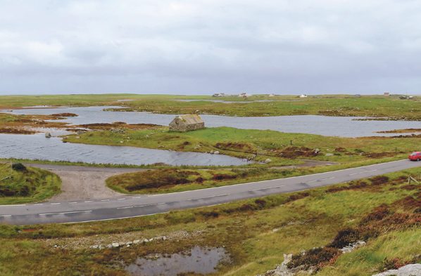
There is a certain loch on the Isle of South Uist, within Howmore township at NF 76 36, whose name made its cartographic debut as ‘Loch Rigarey’ on the ‘Plan of the Island of South Uist’, surveyed 1805 by Wm Bald, a 17-year-old prodigy from Burntisland, Fife. By the time of the O.S. 1st Edition, the loch had been divided into two parts by the building of the road, now the A865, and the two resultant lochs now had individual names. The name ‘chosen’ by O.S. for the main loch had evolved into Loch Rigarry – from the Name Book options of Loch Rigarry (Neil McIntyre’s suggestion), Loch Rigary (from the Admiralty Chart), Loch Rigarey (from Johnston’s map) or Loch Righarruidh (suggested by A. A. Carmichael, with a note to check this spelling, so possibly Loch Righaraidh). The secondary, eastern loch was now called Loch Eilean a’ Ghille-ruaidh. There was also a school marked adjacent to the township road junction, some 200 metres south of the loch.
In the 1921-30 ‘new’ 1-inch survey, the names remained unchanged, but on a small promontory to the west of the main road, a ‘new’ building group – a small farmstead and outbuildings – are now marked, although the school has not changed its position. During the 20th Century, the angling on South Uist became more important, and the loch began to be referred to as ‘Schoolhouse Loch’ – wrongly identifying the now disused farmstead as a former small schoolhouse. It is likely the name was chosen to avoid any potential Gaelic pronunciation problems. By taking this step, the loch immediately lost its provenance and past, but for this loch, things are about to get worse.
The publication of the new Explorer maps came along, and with that, the desire to reinvigorate the Gaelic names of features on the maps as important cultural features. So, once again, the loch’s name has been changed – and is now proudly (?) sporting the name of Loch an Taigh-Sgoil, marked against the southern portion of the loch. The position of the name “Loch Eilean a’ Ghille-ruaidh” has also been now moved to the West of the main road, which itself has been straightened, widened and repositioned some 20-50 metres east, and now seems to refer to the northern section of the main loch, not the sectioned-off eastern portion.
So, clarity or madness? Should an English name, given to a loch to avoid potential embarrassment of tourists, be translated into Gaelic and gain ‘official’ recognition in a Crown document, erasing all mention of the original Gaelic roots? Or would it be better to retain the Gaelic name – preferably going with a version of Carmichael’s suggestion Righaraidh (King’s Hut or King’s Shieling) – and give it the subsidiary English alternative of Schoolhouse Loch (even though the schoolhouse was never there!).
Were the original phonetic Gaelic suggestions true to the intended origins? The -garry suffix is most commonly from Gearraidh – a term for the intermediate land twixt Machair (the coastal strip of blown shell-sand cover) and Monadh (the peaty marshland pasture). And what of the now anonymous Eastern loch? Perhaps we should adopt a plan of simplicity and just call it ‘Fred’.
All maps referred to in the text are available on the National Library of Scotland at https://maps.nls.uk/
O.S. Name Books can be accessed and interrogated online at https://scotlandsplaces.gov.uk/
Edward Dwelly’s Illustrated Gaelic-English Dictionary was used for referencing translations as needed.
Simon M. Davies has lived on South Uist since 2004 and has had a keen interest in the archaeological, historical and cultural heritage of the West Highlands and the Isles since childhood. He is currently the Chair of the Uist Community Archaeology Group and an active member of ACFA, a national group of field archaeologists specialising in surveying and recording the archaeological landscapes of both mainland Scotland and the Isles.